No Image Lot 80 Cary, John "Cary's Traveller's Companion or a Delineation of the Turnpike Roads of England and 80Cary, John "Cary's Traveller's Companion or a Delineation of the Turnpike Roads of England and Cotswold Auction Company Cary, John "Cary's Traveller's Companion or a Delineation of the Turnpike Roads of England and Wales....." London Printed for John Cary Map and Pr... Add to watchlist Live
Reserve not met No Image Lot 178 South Devon Torbay Brixham Paignton John Cary’s Antique 1794 Map-3. 178South Devon Torbay Brixham Paignton John Cary’s Antique 1794 Map-3. William George Title: South Devon Torbay Brixham Paignton John Cary’s Antique 1794 Map-3.Description: South Devon Torbay Brixham Paignton John Cary’s Antiqu... Add to watchlist Timed
Reserve not met No Image Lot 180 Lundy Island Camelford Launceston Cornwall & Devon Antique 230 Yrs Old Map. 180Lundy Island Camelford Launceston Cornwall & Devon Antique 230 Yrs Old Map. William George Title: Lundy Island Camelford Launceston Cornwall & Devon Antique 230 Yrs Old Map.Description: Lundy Island Camelford Launceston John Cary's... Add to watchlist Timed
Reserve not met No Image Lot 181 Dorset Coast Weymouth Portland John Cary's Antique 230 Yrs Old Map-5. 181Dorset Coast Weymouth Portland John Cary's Antique 230 Yrs Old Map-5. William George Title: Dorset Coast Weymouth Portland John Cary's Antique 230 Yrs Old Map-5.Description: Dorset Coast Weymouth Portland John Cary's Antique 2... Add to watchlist Timed
Reserve not met No Image Lot 182 Dover Straits Channel Ports Calais John Cary's Antique 230 Yrs Old Map. 182Dover Straits Channel Ports Calais John Cary's Antique 230 Yrs Old Map. William George Title: Dover Straits Channel Ports Calais John Cary's Antique 230 Yrs Old Map.Description: Dover Straits Channel Ports Calais John Cary's Ant... Add to watchlist Timed
Reserve not met No Image Lot 183 East Anglia Norfolk Suffolk John Cary's Antique 230 Yrs Old Map-35. 183East Anglia Norfolk Suffolk John Cary's Antique 230 Yrs Old Map-35. William George Title: East Anglia Norfolk Suffolk John Cary's Antique 230 Yrs Old Map-35.Description: East Anglia Norfolk Suffolk John Cary's Antique 230 Yr... Add to watchlist Timed
Reserve not met No Image Lot 184 Isle Of Wright St Lawrence Niton Chale John Cary's Antique 230 Yrs Old Map. 184Isle Of Wright St Lawrence Niton Chale John Cary's Antique 230 Yrs Old Map. William George Title: Isle Of Wright St Lawrence Niton Chale John Cary's Antique 230 Yrs Old Map.Description: Isle Of Wright St Lawrence Niton Chale John Ca... Add to watchlist Timed
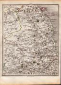
Reserve not met No Image Lot 185 Lincolnshire Lincoln, Grantham, Boston John Cary's Antique 230 Yrs Old Map. 185Lincolnshire Lincoln, Grantham, Boston John Cary's Antique 230 Yrs Old Map. William George Title: Lincolnshire Lincoln, Grantham, Boston John Cary's Antique 230 Yrs Old Map.Description: Lincolnshire Lincoln, Grantham, Boston John Ca... Add to watchlist Timed
Reserve not met No Image Lot 186 Isle of Man South Douglas Peeltown John Cary’s Antique 1794 Map-56. 186Isle of Man South Douglas Peeltown John Cary’s Antique 1794 Map-56. William George Title: Isle of Man South Douglas Peeltown John Cary’s Antique 1794 Map-56.Description: Isle of Man South Douglas Peeltown John Cary’s Antique... Add to watchlist Timed
Reserve not met No Image Lot 187 Isle of Man South Douglas, Port Erin John Cary’s King George III 1794 Map-47. 187Isle of Man South Douglas, Port Erin John Cary’s King George III 1794 Map-47. William George Title: Isle of Man South Douglas, Port Erin John Cary’s King George III 1794 Map-47.Description: Isle of Man South Douglas, Port Erin John Ca... Add to watchlist Timed
Reserve not met No Image Lot 188 Scarborough, Filey, Cayton, Robin Hoods Bay Antique King George III 1794 Map-61. 188Scarborough, Filey, Cayton, Robin Hoods Bay Antique King George III 1794 Map-61. William George Title: Scarborough, Filey, Cayton, Robin Hoods Bay Antique King George III 1794 Map-61.Description: Scarborough, Filey, Cayton, Robin Hoods B... Add to watchlist Timed
Reserve not met No Image Lot 189 Lake District Kendal Cumbria John Cary's Antique King George III 1794 Map-58. 189Lake District Kendal Cumbria John Cary's Antique King George III 1794 Map-58. William George Title: Lake District Kendal Cumbria John Cary's Antique King George III 1794 Map-58.Description: Lake District Kendal Cumbria John Cary's Ant... Add to watchlist Timed
Reserve not met No Image Lot 190 Cumbria & The Scottish Coast John Cary’s Antique Rare George III 230 Yrs Old Map. 190Cumbria & The Scottish Coast John Cary’s Antique Rare George III 230 Yrs Old Map. William George Title: Cumbria & The Scottish Coast John Cary’s Antique Rare George III 230 Yrs Old Map.Description: Cumbria & The Scottish Coast John Cary’s... Add to watchlist Timed
Reserve not met No Image Lot 191 Northumberland John Cary’s Antique Rare George III 230 Yrs Old Map. 191Northumberland John Cary’s Antique Rare George III 230 Yrs Old Map. William George Title: Northumberland John Cary’s Antique Rare George III 230 Yrs Old Map.Description: Northumberland John Cary’s Antique Rare George III 230... Add to watchlist Timed
Reserve not met No Image Lot 192 Newcastle Gateshead Chester Le Street Antique King George III 1794 Map. 192Newcastle Gateshead Chester Le Street Antique King George III 1794 Map. William George Title: Newcastle Gateshead Chester Le Street Antique King George III 1794 Map.Description: Newcastle Gateshead Chester Le Street Antique King... Add to watchlist Timed
Reserve not met No Image Lot 193 Blyth Tynemouth Shields Newbiggin John Cary’s 230 Yrs Old Antique Map. 193Blyth Tynemouth Shields Newbiggin John Cary’s 230 Yrs Old Antique Map. William George Title: Blyth Tynemouth Shields Newbiggin John Cary’s 230 Yrs Old Antique Map.Description: Blyth Tynemouth Shields Newbiggin John Cary’s 230... Add to watchlist Timed
Reserve not met No Image Lot 194 Ireland Dublin, Wicklow, Arklow, John Cary’s Antique 230 Yrs Old Map. 194Ireland Dublin, Wicklow, Arklow, John Cary’s Antique 230 Yrs Old Map. William George Title: Ireland Dublin, Wicklow, Arklow, John Cary’s Antique 230 Yrs Old Map.Description: Ireland Dublin, Wicklow, Arklow, John Cary’s Antique... Add to watchlist Timed
Reserve not met No Image Lot 195 Newry, Carlingford Drogheda John Cary’s Antique 230 Yrs Old Map. 195Newry, Carlingford Drogheda John Cary’s Antique 230 Yrs Old Map. William George Title: Newry, Carlingford Drogheda John Cary’s Antique 230 Yrs Old Map.Description: Newry, Carlingford Drogheda John Cary’s Antique 230 Yrs O... Add to watchlist Timed
Reserve not met No Image Lot 196 Ulster Belfast Downpatrick Strangford Loch John Cary’s Antique 1794 Map-55. 196Ulster Belfast Downpatrick Strangford Loch John Cary’s Antique 1794 Map-55. William George Title: Ulster Belfast Downpatrick Strangford Loch John Cary’s Antique 1794 Map-55.Description: Ulster Belfast Downpatrick Strangford Loch Joh... Add to watchlist Timed
Reserve not met No Image Lot 197 Ulster Larne, Rathin Isle, Mull Of Kintyre John Cary’s Antique 1794 Map-64. 197Ulster Larne, Rathin Isle, Mull Of Kintyre John Cary’s Antique 1794 Map-64. William George Title: Ulster Larne, Rathin Isle, Mull Of Kintyre John Cary’s Antique 1794 Map-64.Description: Ulster Larne, Rathin Isle, Mull Of Kintyre Joh... Add to watchlist Timed
Reserve not met No Image Lot 198 Gretna Green Jedburgh Lockerbie Selkirk - John Cary’s Antique 1794 Map-67. 198Gretna Green Jedburgh Lockerbie Selkirk - John Cary’s Antique 1794 Map-67. William George Title: Gretna Green Jedburgh Lockerbie Selkirk - John Cary’s Antique 1794 Map-67.Description: Gretna Green Jedburgh Lockerbie Selkirk - John ... Add to watchlist Timed
Reserve not met No Image Lot 199 Berwickshire Dunbar Berwick on Tweed Eyemouth John Cary's Map of 1794-77. 199Berwickshire Dunbar Berwick on Tweed Eyemouth John Cary's Map of 1794-77. William George Title: Berwickshire Dunbar Berwick on Tweed Eyemouth John Cary's Map of 1794-77.Description: Berwickshire Dunbar Berwick on Tweed Eyemouth Jo... Add to watchlist Timed
Reserve not met No Image Lot 200 Anglesey Dulas Bay & Harbour Wales John Cary's Antique 230 Yrs Old Map-48. 200Anglesey Dulas Bay & Harbour Wales John Cary's Antique 230 Yrs Old Map-48. William George Title: Anglesey Dulas Bay & Harbour Wales John Cary's Antique 230 Yrs Old Map-48.Description: Anglesey Dulas Bay & Harbour Wales John Cary's ... Add to watchlist Timed
Reserve not met No Image Lot 201 Caernarfon Bay Anglesey Holyhead Pwllheli-John Cary’s Antique 1794 Map. 201Caernarfon Bay Anglesey Holyhead Pwllheli-John Cary’s Antique 1794 Map. William George Title: Caernarfon Bay Anglesey Holyhead Pwllheli-John Cary’s Antique 1794 Map.Description: Caernarfon Bay Anglesey Holyhead Pwllheli-John Car... Add to watchlist Timed
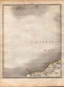
Reserve not met No Image Lot 202 Cardigan Bay Aberporth New Quay John Cary’s Antique 1794 Map-29. 202Cardigan Bay Aberporth New Quay John Cary’s Antique 1794 Map-29. William George Title: Cardigan Bay Aberporth New Quay John Cary’s Antique 1794 Map-29.Description: Cardigan Bay Aberporth New Quay John Cary’s Antique 1794 ... Add to watchlist Timed
Reserve not met No Image Lot 203 Pembrokeshire Coast Wales John Cary’s Antique King George III 1794 Map-19. 203Pembrokeshire Coast Wales John Cary’s Antique King George III 1794 Map-19. William George Title: Pembrokeshire Coast Wales John Cary’s Antique King George III 1794 Map-19.Description: Pembrokeshire Coast Wales John Cary’s Antique K... Add to watchlist Timed
No Image Lot 397 Map of Herefordshire by Robert Morden, handcoloured, 36cm x 41cm, 'Barkshire' by Robert Morden 397Map of Herefordshire by Robert Morden, handcoloured, 36cm x 41cm, 'Barkshire' by Robert Morden Cotswold Auction Company Map of Herefordshire by Robert Morden, handcoloured, 36cm x 41cm, 'Barkshire' by Robert Morden handcoloured map, 37cm x 44cm and Rutland 'Routelan... Add to watchlist Live
No Image Lot 398 Map by Robert Morden, Hampshire, handcoloured, 36cm x 43cm, a strip map by John Ogilby 'Hereford 398Map by Robert Morden, Hampshire, handcoloured, 36cm x 43cm, a strip map by John Ogilby 'Hereford Cotswold Auction Company Map by Robert Morden, Hampshire, handcoloured, 36cm x 43cm, a strip map by John Ogilby 'Hereford to Leicester', circa 1675, 34cm x 45cm, unframed ... Add to watchlist Live
No Image Lot 399 Map of 'Merionethshire' by John Speed, circa 1610, 43cm x 52cm, unframed and a map of 'The Fennes' 399Map of 'Merionethshire' by John Speed, circa 1610, 43cm x 52cm, unframed and a map of 'The Fennes' Cotswold Auction Company Map of 'Merionethshire' by John Speed, circa 1610, 43cm x 52cm, unframed and a map of 'The Fennes' by Ioannis Ianbonii, circa 1650, 44cm x 56cm, u... Add to watchlist Live