Lotto 111
After S. Bellin, 'Carte Du Comté De Kent Et Du Pas De Calais', hand-coloured engraved map, image
After S. Bellin,'Carte Du Comté De Kent Et Du Pas De Calais',hand-coloured engraved map,image 60 x 90 cm
After S. Bellin,'Carte Du Comté De Kent Et Du Pas De Calais',hand-coloured engraved map,image 60 x 90 cm
A needlework map of Engalnd & Wales by Lucy Elizabeth Depeat, aged 9, 1890, image 73 x 73 cm, together with another similar map (2)
After Pieter van der Aa (Dutch, 1659-1733),'Latium Campania et Samnium cum Forum Circum Adjacentibus Regionibus',hand-coloured engraved map,image ...
After Christopher Saxton and Philip Lea,a hand-coloured engraved map of 'Glocestershire' [sic],image 38 x 49 cm
A beautiful signed limited edition print by Jeremy King, Punting on the Cambridge river, 241 of 250, frame size 81 x 62cm
1967 coloured print of Saxton's Map of Somerset, 1575 by Taylowe Limited. Framed and glazed, measuring approx. 53.5cm x 65.5cm.
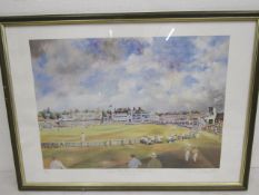
England V West Indies ltd edition print, Trent Bridge 1995 by Jocelyn Galsworthy, signed and numbered in margin 64x46cm
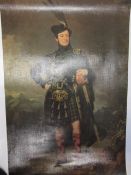
After Robert McInnes (1838), fine textured Selby print portrait of Lt. Col. James Moray
C1720 Latium Campania et Samnium by AA, Pieter van der - Map engraving of ancient Italy with later colouring, framed and glazed. Complete with cer...
Bristol Museum and Art Gallery - Late 20th century book of photographs of maps from the collection at Bristol Museum. Including The Citte of Brist...
John Ogilby : The Road from Tinmouth in Northumberland to the City of Carlisle in Cumberland, strip map, engraved and hand-coloured, 1698, 33cm by...
Cartography - a mounted Royal Atlas of England & Whales (plate no.52) map of Birmingham by John Bartholomew & Co, 44 x 34cm
END OF SALE, THANK YOU FOR YOUR BIDDING. OUR NEXT SALE IS ON THE WEDNESDAY 11TH AND THURSDAY 12TH JUNE


![After Christopher Saxton and Philip Lea, a hand-coloured engraved map of 'Glocestershire' [sic],](https://portal-images.azureedge.net/auctions-2025/whpav12190/images/c43f84c3-fa6b-42c4-bd5f-b2c301157fc5.jpg?h=175)